|
USK
WALKS
|

|
|
|||||||
| HOMEPAGE |
|
Walk No 20: Usk Valley
Walk - Clytha Castle - Coed y Bwnydd - Boots are essential
for this walk as stretches of it are often very muddy. |
||
|
This is a strenuous but rewarding walk
with several moderate climbs. It follows the route of the popular Usk
Valley Walk and then returns through hilly farmland and woods to the north
of Usk. From the hilly sections there are excellent views of the countryside
to the north and west. |
||
|
Leave the town square by turning left
on the main road. Cross the river and take the steps at the end of the
bridge up and then down to the river bank. Walk along the river bank
and go under the old railway bridge. From this point the Usk Valley
Walk is obvious and well signposted. After 3 kms, where the path joins
a lane at Estavarney Farm, it is necessary to walk westward along the
lane for 600 metres, passing farm buildings on the left, before crossing
the stile
on the right. Follow Usk Valley Walk waymarks across fields, through
a small wood and along the riverbank (a distance of 2.7 kms from the
stile). Turn right on a lane, soon crossing Chain Bridge. Turn left
on a lane signposted Bettws Newydd and after 300 metres take the path
on the left to follow the well-marked Usk Valley Walk. |
|
|
|
|
||
 Clytha Castle |
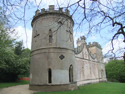
After 3.2 kms, at a green metal kissing gate near the river, where the Usk Valley Walk continues left, turn right on a path, soon passing the Clytha Car Park. Turn left on the road and after a short distance go through a metal gate on the right. Go slightly left, following the National Trust waymark posts. Just after a large bush turn right uphill at a short, wooden post. Continue along the edge of the slope with trees on the right and go through a wooden gate signposted Coed y Bwnydd. Follow the loop path round to the left, soon approaching Clytha Castle. (This is a folly built in 1790, owned by the National Trust and leased to The Landmark Trust for use as holiday accommodation.) | |
|
Just to the right (east) of the castle turn right on a track signposted Coed y Bwnydd and after 30 metres turn right on a narrow path through the wood, signposted Coed y Bwnydd. Soon go through a kissing gate and take the usually obvious path across the field. (If the path is hidden by crop growth, then it would be courteous to the farmer to walk round 2 sides of the field.) Cross a stile and a narrow fence section at the upper corner of the field and turn right, keeping a wire fence on the right. At the field corner, by a metal gate, turn left (don't go through the gate), keeping a wire fence on the right. Continue with a wood on the right. After climbing for some distance, cross a stile and keep right, soon crossing another stile. Soon go through a kissing gate and turn right on a lane. |
||
|
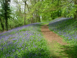
Go uphill for some distance and cross
a stile on the right marked "This is a permissive path only."
Go to the right of a barn and through a small gate to enter Coed
y Bwnydd (a National Trust site and Iron Age hillfort). This wooded
hill makes a pleasant detour and picnic stop, especially in spring when
the bluebells are magnificent. The circular path can be followed in either
direction, the right side being much longer. Leave the site through a
small gate and turn right on the lane.
|
|
|
|
|
Where the lane swings right, turn left
and after 15 metres cross a stile on the right. Follow the indicated direction
across the field on an obvious path and cross a stile near the corner
of the field. Go straight on, cross another stile and turn left. Go down
the field with a wire fence on the left. Cross 2 stiles 40 metres apart
(with adjacent metal gates often left open) and turn right. Cross a stile
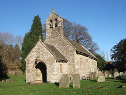
at the end of a stone wall to enter Bettws Newydd churchyard. (There are
seats here so this makes a pleasant place for a rest.) Cross a stile at
the south-west corner of the churchyard and follow the path across a field.
Go through a gate and turn left on a lane.
|
|
| After passing Brook House on the left, cross a stile on the left to the right of a wooden gate. Go straight ahead with trees on the right. In the far right corner of the field cross a stile and take the indicated direction half right across the field. Cross a stile to the right of a metal gate and turn left, aiming between 2 well-spaced trees in the middle of the field (not the 2 larger trees closer together). Cross a stile in a row of trees below the crest of the hill. Go half left, aiming for the end of a hedge. Follow the hedge round to the right by a water trough. |
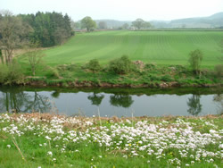
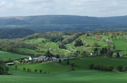 Usk Valley (view from the hill to be climbed) |
|
|
Cross a stile to the right of a metal gate and go straight on. Turn left just before a large barn, then right to pass farm buildings. Cross a stile to the left of a metal gate and go left down a track which soon climbs. Shortly after the track to Russell Hill Farm take a grassy track on the right at a bend. This becomes stony and can be slippery in wet conditions. Go down a lane and soon turn right at the junction with another. Go down a long hill and left on a lane at the bottom. Turn right at crossroads and after about 10 minutes, at a bend, take the signposted path to the right through a wooden gate alongside the garage next to the white house. |
||
| Turn left and head for a large tree at the field edge. Continue in the same direction with trees and a hedge on the left. Cross a stile and continue 50 metres on a grassy section to a narrow wooden bridge on the right (hidden by large bushes until you are very close as it is in a dip). Cross it and turn half left. Go through a metal gate and head half right for 2 distant power-line poles. Go through a metal gate (often left open) and head for the power-line poles. Head for the far left corner of the field. |
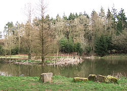 The pond on the north edge of Lady Hill Wood |
|
| Cross a stile and go straight on, soon crossing another stile. Go a short distance and cross another stile. After 25 metres go through a metal gate on the left and turn left. Follow the track round to the right, crossing a stream, and immediately take the fork to the right uphill (Kitty Beech Rd). Cross over another track and go uphill. Go through a metal gate at the edge of Lady Hill Wood and turn right. Go through a metal gate and straight ahead on a muddy track which curves left, soon passing a small pond on the right. | ||
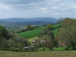 Usk Valley (view from the gate mentioned opposite) |
Go through a wooden gate at the edge of the wood (often left open) and straight ahead on a broad track. Go through a wooden gate (often left open). Note the blue plaque off to the right commemorating the Battle of Pwll Melyn in 1405. Go down the track to the left of Castle Farm, through a metal gate, then through a small wooden gate and then another small gate to the left of a larger wooden gate. Turn left on the lane and shortly rejoin the main road. Turn right to return to the town square. |
|
|
A
laminated A5 card showing this walk route, along with photographs, can
be easily ordered here.
The walk can be ordered more cheaply in digital format (PDF file) on the alternative Order Form. |
return
to top >>>
Page last updated 06.05.25