Image copyright, John Tallet, 2003.  Click to return to the Homepage.
USK WALKS
Welsh flag
HOMEPAGE
ABOUT USINDEX OF WALKSLOCAL LINKSMAPS MISCELLANEOUS
WALK 1 WALK 2WALK 3WALK 4WALK 5WALK 6WALK 7 WALK 8 WALK 9WALK 10
WALK 11WALK 12
WALK 13 WALK 14 WALK 15 WALK 16 WALK 17 WALK 18 WALK 19 WALK 20

Walk No 10a: Usk Flood Route - The Rat Trap - Llandenny - Gwehelog
(9 miles - about 3 hours)
(Minor modifications to the route made on 16.12.09 and 11.12.10.)

Boots are essential for this walk as the fields are usually boggy in places.


This is a substantial walk with a few moderate climbs, across farmland and following very quiet country lanes.
Refreshments can be obtained at three pubs on or near the route (in addition to those in Usk itself).

North of the Flood Route crossroads
North of the Flood Route crossroads on a
beautiful April afternoon - see an enlargement

Leave the town square by the south east corner and proceed along Four Ash Street. Pass the Greyhound Inn (now closed) and continue on Chepstow Road. Turn right at The Olway Inn Hotel (formerly Casey's Court). 
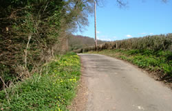
Continue along the lane, crossing above the dual carriageway. Turn left at the crossroads, where the Flood Route is signposted.
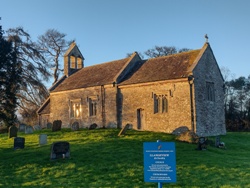
(A 1½ mile extension to this itinerary can be made but it involves a long steep climb and a very boggy track - see text-only file (Walk 10b) which includes this extension.)


After a few minutes you will see St David's Church on the left. Shortly after passing a house called 'The Yews' on the right, at a bend take the footpath to the left, crossing the stream by a small wooden bridge.

Turn right and head for the corner of the field diagonally opposite. Cross the stream by a wooden bridge and turn left on the lane.


St David's Church, Llangeview


Turn right on the main road (B4235) and continue for 5 minutes. Shortly after passing the Rat Trap hotel, go through a small wooden gate on the left and head half right across the field to a gated footbridge. After crossing the brook, head half right for the more distant, large tree and the far corner of the field, where there is a road bridge over the dual carriageway. Go through the tunnel (with metal gates at each end) under the minor road and follow the field edge with the brook on the left. Cross the stile into the South Wales Gliding Club's field. Take extreme care when there is gliding activity in progress. (See a photo of the Club's Pawnee tug (tow plane).)


The Raglan Arms in Llandenny
The Raglan Arms, Llandenny


Keep to the left edge of the field, still alongside the brook. Where there is a yellow warning notice about the danger from aircraft, turn left and go through 2 metal gates close together. Head slightly left to the far corner of the field.

Go through the metal gate, immediately cross the brook and follow the track to the right which crosses the dual carriageway and leads to the tiny village of Llandenny.

Turn left on the road at The Raglan Arms (tel. 01291 690800); this pub, which serves sophisticated food, is closed on Sunday evening and all day Monday.


Keep straight on at the junction, signposted Cold Harbour, and after about half a mile, just before the crossroads, go through
the kissing gate on the left into Kitty's Orchard (Gwent Wildlife Trust Nature Reserve). Follow the path to a kissing gate and then keep to the left side of the field. At a metal gate near the third large tree, turn right and head for a stile in front of a white house. Turn right on the lane and, shortly after, left on the larger lane.


Llandenny
Llandenny
(See a photo taken in the opposite direction.)

Near the area called Llandenny Walks


After about a mile, at the junction near a yellow gravel bin, go straight uphill. At the top of the hill cross a stile on the left.

(If, instead of turning left, you take the road to the right at this point, you will soon come to the Hall Inn. A good choice of meals can be had here. Return to the stile by the Give Way sign if you make this detour.)

 
Go straight ahead, passing to the left of double telegraph poles and a line of trees. Cross a stile to the left of a metal gate and take the track ahead through the wood, which has a beautiful display of bluebells in the Spring. Cross a stile, go through a small orchard and cross another stile. Go straight ahead on the lane and after 40 metres cross a stile on the left.  
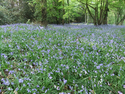
Bluebells in the wood

Turn right, cross the field and cross a stile to the left of a tree. Go slightly left, heading for a large tree with a double trunk. Continue in approximately the same direction, heading for a red brick farmhouse. Go downhill and through a wide gap in the line of trees where there are remnants of an old fence. Head for the red brick house and cross a stile by a large tree to the left of the house. Turn right on the lane, eventually passing the allotments. Turn left on the main road and follow it back to Usk centre.


A printed, laminated card showing this walk route, along with relevant photographs, is available at £1.00 from the Usk Rural Life Museum in New Market Street and from the Usk Library at 18A Maryport Street, Usk, NP15 1AE (Tel. 01291 674925, Fax: 01291 674924). If it is more convenient, the card can be ordered by completing the easy-to-use Order Form. It can also be ordered more cheaply in digital format (PDF file) on the alternative Order Form.

return to top >>>

WALK 1 WALK 2WALK 3WALK 4WALK 5WALK 6WALK 7 WALK 8 WALK 9WALK 10
WALK 11WALK 12
WALK 13 WALK 14 WALK 15 WALK 16 WALK 17 WALK 18 WALK 19 WALK 20

Page last updated 18.12.11