|
USK
WALKS
|

|
|
|||||||
| HOMEPAGE |
|
Walk
No 14: Llangeview - Coed Cwnwr - Nant-y-Banw - Llanllowell - Usk Flood
Route
(8½ miles - about 3 hours; route shortened on 27.01.24; last checked (not revised) on 22.04.25) Boots are recommended for this walk as it includes a rough and muddy track. |
||
|
This is a
long walk mainly on quiet lanes, with some climbing. |
||
|
|
|
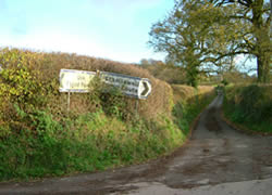
Leave the town square by the south east corner (i.e. the same side of the square as the Castle Inn) and proceed along Four Ash Street. Pass the former Greyhound Inn (now a house) and continue on Chepstow Road. Turn right at the Olway Inn. Continue along the lane, crossing above the dual carriageway. At the crossroads (where the Flood Route is signposted in two directions) go straight up the narrow lane. Continue uphill, ignoring after about 120 metres the parallel track on the right which leads to a house.
|
|
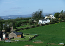
At "Graig-Yr-Ieir" house (the white house at the end of the lane) take the narrow, muddy and stony track up the hill, through Mardy Hill Wood. At the top follow the track with a field to the left and a hedge to the right. When visibility is good, there are splendid views from here across to the hills surrounding Abergavenny. Shortly after the next house on the left follow the track round to the right. Pass the entrance to the Springdale Farm Nature Reserve (Gwent Wildlife Trust). Join a lane in the hamlet of Coed Cwnwr and continue ahead uphill. Shortly take the first lane on the right. Ignore the track on the right and soon pass Ty-Wilson Farm. After passing a house called Ty Gwyn, take the lane to the right marked with a dead end sign. After 6 minutes take a track to the right where there are gas pipeline notices on the left. This soon narrows and becomes a muddy path.
|
|
|
|
|
|
Descend through a deep gulley with steep sides. (The most difficult section can be avoided by taking a parallel path on the right.) Follow a stream for a short distance and swing right uphill on a rutted track. Continue on the track which soon becomes a lane. Pass Fernhill Farm and a house called Ty-Gatta and follow the lane down to a junction. Turn right on the road and go straight on at the next junction. (This road can be fairly busy at times and there is no pavement.) |
|
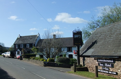
Pass Forge Garage and the Greyhound Inn and after the bend soon reach the hamlet of Llanllowell. Opposite St Llywel's Church take the lane on the right (signposted Usk Flood Route). Follow this for 1 mile and turn left at the crossroads (signposted Usk Flood Route). Follow this to the T-junction by the Olway Inn and turn left. Follow the road back to the town square. |
 The Olway Inn, Usk |
|
|
A
laminated A5 card showing this walk route, along with photographs, can
be easily ordered here.
The walk can be ordered more cheaply in digital format (PDF file) on the alternative Order Form. |
|
return
to top >>>
|