|
USK
WALKS
|

|
|
|||||||
| HOMEPAGE |
|
Walk No 8: Llancayo
- Trostrey Common - Gwehelog This walk
takes you initially alongside the River Usk and then on quiet country
lanes past a few farms and hamlets. There are three climbs, one of them
quite long but none of them severe. There is a pub with excellent food
after about 5 miles. |
||
|
|
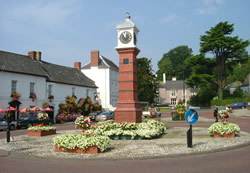
Turn left out of the town square and walk along the main road to the bridge over the river. Take the path called "Conigar Walk" down to the riverbank just before the bridge. (See a
photo of a commemorative plaque giving the history of the bridge and
another
explaining the origin of "Conigar Walk".) |
|
|
Where the pavement ends, either continue along the grass verge or cross to the other side to face oncoming traffic; after 5 minutes take the first right turn signposted Trostrey Common. (NB: The destination board is loose on its pole and often gets blown 90° so that it is pointing up the main road; if this is the case, please turn it to point to the lane.) |
|
|
|
|
||
|
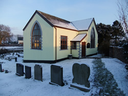
After passing Upper House, follow the lane round to the right, passing 3 connected corrugated iron sheds. Go downhill and at the bottom follow the lane round to the left, ignoring a track on the left where "Cherry Tree" is signposted. Turn left at the T-junction and climb the hill. Just after the Gwehelog Methodist Church (built in 1822) take the right turn at the crossroads.
|
|
|
|
|
|
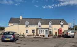
Just after
Ty-Gwyn Farm (on the left) take the first lane on the left (Wainfield
Lane). After 0.6 mile turn right on the main road. Turn left opposite
the Hall Inn (a wide range of excellent dishes can be had here) on to
Ty-Freeman Road. |
|
Continue along the lane for 2 miles, pass the allotments and then turn left on the main road. Follow it back to Usk centre. |
||
|
A
laminated A5 card showing this walk route, along with photographs, can
be easily ordered here.
The walk can be ordered more cheaply in digital format (PDF file) on the alternative Order Form. |
|
return
to top >>>
|
Page last updated 28.03.26