|
USK
WALKS
|

|
|
|||||||
| HOMEPAGE |
|
Walk
No 2: Both banks of the River Usk |
|||
|
|
|||
|
|
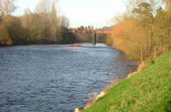
Turn left out of the town square and proceed on the main road to the bridge over the river. Take the sloping path ("Conigar Walk") down to the riverbank just before the bridge. (See a photo of a commemorative plaque giving the history of the bridge and another explaining the origin of "Conigar Walk".)
|
||
|
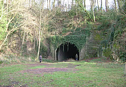
Follow this path to the end and turn left on the Abergavenny Road. Take the footpath (“Old Station Walk”) to the right immediately before the old railway bridge. Follow the path round to the left at the small clearing. You will see the old railway tunnel entrance on the right. Take the path to the left along the route of the former railway line. Cross the river on the railway bridge and take the steps down at the end of it. (The line was closed to passengers on 30.05.55. A centenary special train was run on 12.10.57.) |
|
|
|
|
|
|||
|
|
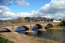
Take the short concrete
path ahead to the grassy area known as Usk Island and continue along the
riverbank in the direction of the road bridge. Take the path with a high
wall to the right towards the road bridge.
Climb the steps at the end, turn left, cross the bridge and at the far end take the path on the left down to the riverbank as before. This time turn left at the bottom, go under the road bridge and walk along the riverbank. Watch out for goosanders which are fairly common on this stretch of the river, especially in winter. |
||
|
After about half a mile, the path rises a little;
at this point follow the path round to the left, then to the right, along
the football field perimeter. Head for the small car park to the left
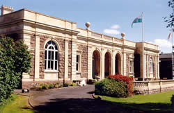
of a white building and turn left on the road. Pass the prison and Sessions
House. (This elegant building was designed by Thomas Henry Wyatt and completed
in 1878. County Quarter Sessions were held there from 1877 to 1950 and
the Magistrates' Court until 1995. The building was opened in January
2000 as the town's Civic Centre.) Turn right at the OneStop supermarket
and return to the town square.
|
|
||
|
A
laminated A5 card showing this walk route, along with photographs, can
be easily ordered here.
The walk can be ordered more cheaply in digital format (PDF file) on the alternative Order Form. |
|
return
to top >>>
|
Page last updated 25.10.25